Revised......
Please make the following release changes to the American River
Date Time From (cfs) To (cfs)
01/10/2017 1600 50,000 55,000
01/10/2017 1700 55,000 60,000


 Administrator
Revised......
Please make the following release changes to the American River
Date Time From (cfs) To (cfs)
01/10/2017 1600 50,000 55,000
01/10/2017 1700 55,000 60,000
Bill Kiene (Boca Grande)
567 Barber Street
Sebastian, Florida 32958
Fly Fishing Travel Consultant
Certified FFF Casting Instructor
Email: billkiene63@gmail.com
Cell: 530/753-5267
Web: www.billkiene.com
Contact me for any reason........
______________________________________
Senior Member
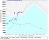
Despite the increased flows, Folsom Lake is really shooting up -- see attached. This article says it gained 100,000 acre feet over the last day, going from 500,000 to 600,000 -- a 20% increase in one day: http://www.folsomtelegraph.com/artic...ng-lake-levels
TroutSource.com
we deliver the river
 Senior Member
And the big push of rain is supposed to come in this evening!
Senior Member
Looks like the potential for another atmospheric river set-up next week:
From NOAA:
Next chance of precipitation begins next Tuesday and continues through the end of the week. Heavy
precipitation possible during the middle of next week with renewed flooding concerns.
Models still showing that another atmospheric river could be aimed
for the West Coast next week. Both the GFS and ECMWF indicate that
the moisture plume should start impacting NorCal sometime Tuesday.
Heavier and more widespread precipitation is forecast to begin by
Wednesday morning and continue through Thursday. Looks like
weather will become more showery on Friday, but another wave of
widespread precipitation would arrive Friday night into Saturday.
Snow levels would initially be high, above 7000 ft, then lower on
Thursday and Friday ranging 3000-4000 ft. Given the already high
river/creek stream levels, flooding will continue to be a concern.
TroutSource.com
we deliver the river
 Posting Permissions


 Reply With Quote
Bookmarks