Page 2 of 2 FirstFirst 12
Results 11 to 15 of 15

Thread: West Carson at Stateline; need advise

  1. #11
    Join Date
    Aug 2011
    Location
    PNW
    Posts
    413

    Default Glory Holes

    Quote Originally Posted by gangster View Post
    DOnt expect others to just give up their hard earned honey holes. Go out and find em.

    We stayed out of the gangster glory holes

  2. #12
    Join Date
    Aug 2011
    Location
    PNW
    Posts
    413

    Default

    Quote Originally Posted by gangster View Post
    GOod to hear ya had fun. And great to see someone that actually uses their suv. SOme fish pics would have been cool too.
    No fish pictures because the river is a bust in that section terrible fishing only a couple of small 5 inchers

  3. #13

    Default

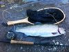
    Sorry for the no fish pics. As usual once I started fishing it was non stop till we left. We did catch several fish, mostly browns and a couple lunkers.
    If anyone is interested in a cast and blast in Oct let me know. One requirement is you need a upland bird dog. My GSP is strong on birds, but more dogs the better. Shoot me a PM.

    Frank

  4. #14
    Join Date
    Jan 2012
    Location
    East Bay
    Posts
    380

    Default

    Quote Originally Posted by DAVID95670 View Post
    How would you access the lower section at the NV Boarder of the E Carson River

    How difficult is the hike down from the Airport to the E Carson River Wild Trout section?

    David, the hike from the airport down to the river is about a mile downhill, some of it on a fire road. If you're going in there alone make sure you tell someone where you'll be, even better give them the GPS coordinates. Once you're down there you'll probably not see another soul for the day and there are rattlers, bears and cats as well as lots of places to fall and break a leg.

    The biggest problem can be afternoon storms. that section of the Sierras seems to get more thunderstorm activity than any other and I've had to run for cover from very large hail a couple of times, and then you have to deal with lighning strikes.

    The hike back out can be tough if its a hot day. Takes about 45 minutes back up the hill. Bring lots of water.

  5. #15
    Join Date
    Feb 2012
    Location
    California
    Posts
    70

    Default

    Quote Originally Posted by Bob Loblaw View Post
    David, the hike from the airport down to the river is about a mile downhill, some of it on a fire road. If you're going in there alone make sure you tell someone where you'll be, even better give them the GPS coordinates. Once you're down there you'll probably not see another soul for the day and there are rattlers, bears and cats as well as lots of places to fall and break a leg.

    The biggest problem can be afternoon storms. that section of the Sierras seems to get more thunderstorm activity than any other and I've had to run for cover from very large hail a couple of times, and then you have to deal with lighning strikes.

    The hike back out can be tough if its a hot day. Takes about 45 minutes back up the hill. Bring lots of water.
    To add to this I would take a SPOT locater along too.

Bookmarks

Posting Permissions

  • You may not post new threads
  • You may not post replies
  • You may not post attachments
  • You may not edit your posts
  •